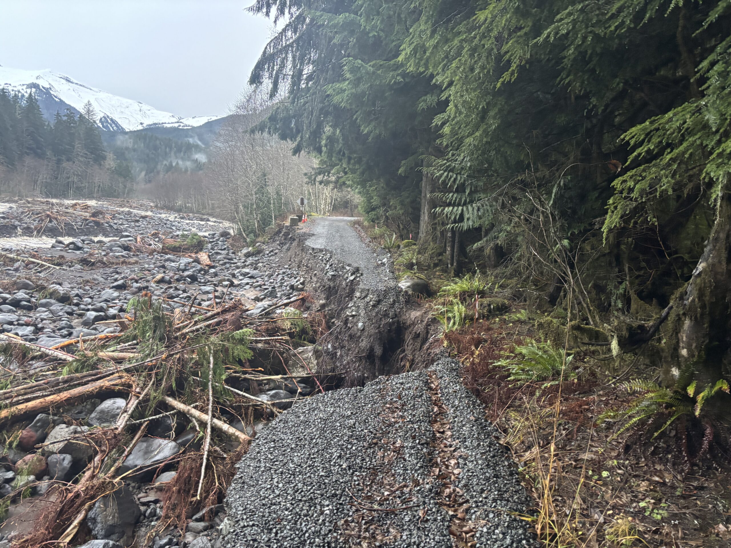
Glacier Creek Road, the primary vehicle access route to the north side of Mount Baker and the trailhead for Heliotrope Ridge, reopened on August 20 after the U.S. Forest Service completed repairs to damage caused by the December 2025 flooding event. Hikers, climbers, and outdoor enthusiasts who have been navigating lengthy approach detours for more than eight months can once again drive to the Heliotrope Ridge trailhead directly.
The road, formally designated as Forest Service Road 39, was one of several access routes in the Mount Baker area damaged during December flooding that caused widespread damage across western Washington. The closure added extra miles and significant additional elevation gain to what is already a demanding approach to one of the region's most popular alpine destinations. For parties traveling on foot from the nearest viable parking area during the closure, the additional distance translated into substantially longer days in the field and, for less experienced visitors, trips that simply were not feasible without the road access they had previously relied on.
Why Glacier Creek Road Matters
Heliotrope Ridge is one of the most heavily visited day hikes on the north side of Mount Baker, offering dramatic views of the Coleman Glacier, the Colfax Glacier, and the summit pyramid of the 10,781-foot volcano. The trail also serves as the primary staging ground for the most popular non-technical ascent route on Mount Baker from the north, the Coleman-Deming route, which draws hundreds of guided and independent climbing parties each season. Reaching the Coleman Glacier terminus and the high camps above it depends entirely on having reasonable access to the Heliotrope Ridge trailhead, making Glacier Creek Road not just a hiking access route but a foundational piece of infrastructure for the regional mountaineering community.
For the Bellingham Mountaineers climbing club, the closure created significant operational disruption. Club member Tim Schafermeyer told Cascadia Daily News contributor Jason Martin earlier this year that the washout "forced the relocation of several instructional trips, making it increasingly difficult to reach the terrain necessary for teaching essential alpine and glacier skills." Those instructional trips are not optional extras for the club: they are how new climbers build the glacier travel, crevasse rescue, and rope management skills that determine whether they can safely attempt Baker and the other glaciated peaks of the North Cascades. Guiding outfits that depend on Coleman Glacier terrain for client trips faced similar logistical challenges throughout the spring and summer climbing season, with some operations rerouting clients to alternate objectives on different peaks while waiting for the road to reopen.
The closure was not the first time Glacier Creek Road has been knocked out by flood damage. The road also washed out in the November 2021 flooding event and did not reopen for several years, frustrating outdoor enthusiasts and commercial guiding operations throughout that period. The repeated flood damage to the same road has raised questions among some outdoor advocates about the long-term resilience of the road's drainage infrastructure in an era of increasingly intense precipitation events. Climate scientists studying the Pacific Northwest have noted that atmospheric river events, which produce the kind of intense rainfall that caused both the 2021 and 2025 flooding, are expected to become more frequent and more severe as global temperatures rise, which raises legitimate questions about how many times a road in this location can be repaired before a more fundamental engineering solution is needed.
What Is Still Closed
Not everything in the area is back to normal. Grouse Butte Road, designated Forest Service Road 36, which branches off FS 39 at mile 7.75, remains closed to motorized vehicles due to damage at mile 0.6. The damage point is close enough to the junction that even a short drive into the road is not possible. Hikers and cyclists may still be able to access Grouse Butte Road on foot or by bike, but vehicle access is not available. Anyone planning a trip that involves Grouse Butte Road should confirm current conditions with the Mount Baker-Snoqualmie National Forest before heading out, as conditions and closure boundaries can change without immediate public notice.
The broader network of Forest Service roads in the Mount Baker area continues to see varying conditions following the December 2025 flooding, and some routes that were not formally closed may still have surface damage, potholes, or washboarding that affects vehicles with low clearance. Travelers heading into the national forest on any unpaved roads should check current road conditions before departing and should have appropriate ground clearance for the route they intend to travel.
Planning Your Visit
With Glacier Creek Road now open, the Heliotrope Ridge trail is fully accessible by vehicle for the remainder of the 2026 hiking and climbing season. The trail typically remains snow-free through summer at lower elevations but retains permanent glacier ice at higher elevations year-round. Day hikers who turn around at the ridge viewpoints above the glacier face a moderately strenuous hike with substantial elevation gain. The views of the Coleman Glacier from the ridge are among the most accessible glacier views in the entire North Cascades, making this trail genuinely worthwhile for hikers who are not planning a summit attempt. Climbers heading onto Coleman Glacier should have crevasse rescue training, appropriate glacier travel equipment, and a current understanding of conditions from climbing trip reports posted through platforms such as The Mountaineers or Mountain Forecast.
A Northwest Forest Pass or America the Beautiful pass is required for parking at the Heliotrope Ridge trailhead. Information on passes and current trail conditions is available through the Mount Baker-Snoqualmie National Forest's ranger district offices and through the Recreation.gov platform. Current wildfire conditions in the Mount Baker area are also relevant to any planned backcountry trip; the Emergency Management briefing published Thursday noted that fire danger remains at Very High in the Cascades, and a Stage 2 burn ban remains in effect county-wide, prohibiting campfires at all elevations regardless of whether you are in a designated campsite or dispersed camping area. More on fire and weather conditions this week is available in our emergency management briefing.