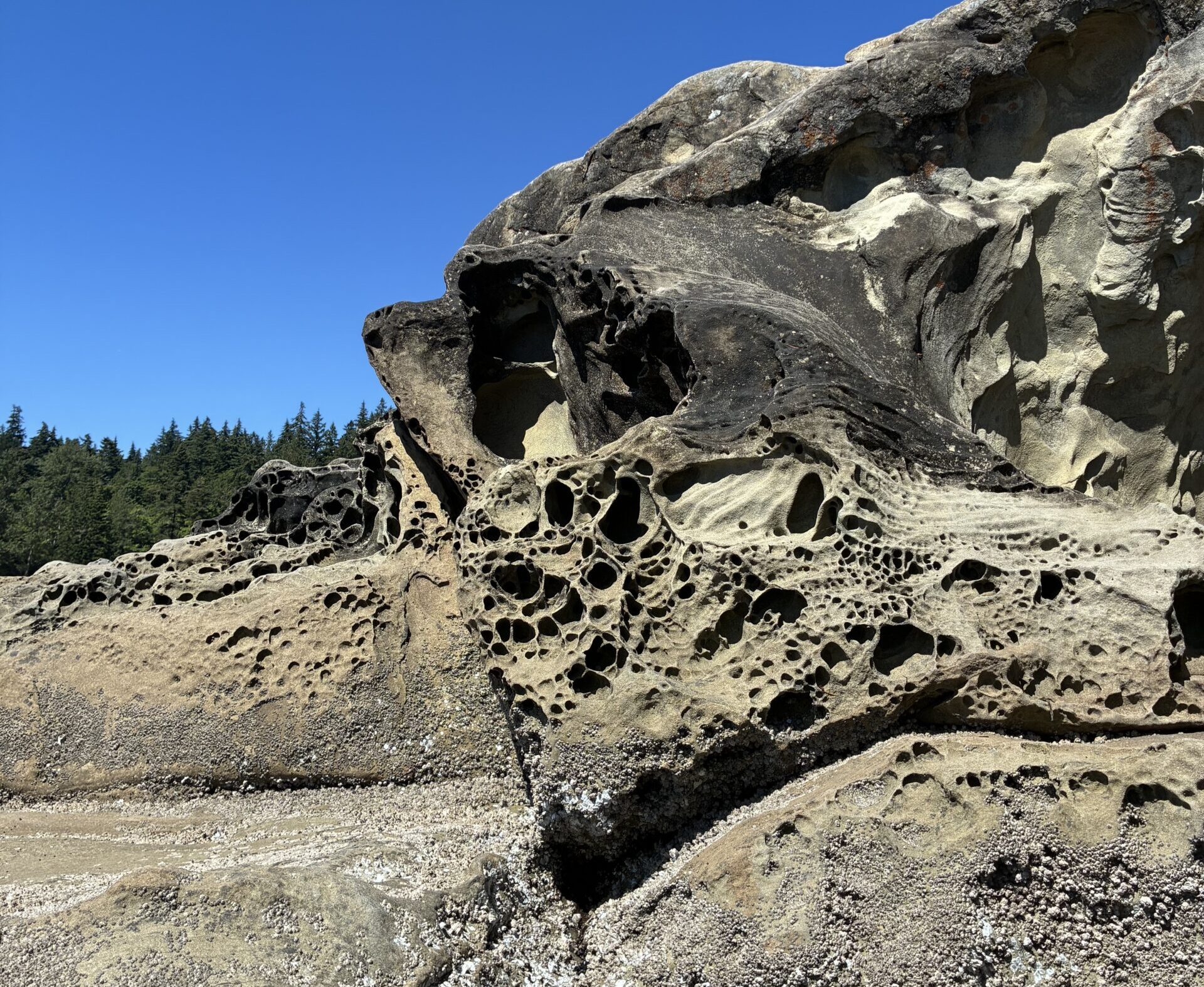
If you have ever paused on the sandstone ledges at Teddy Bear Cove or picked your way along the shoreline at Larrabee State Park and noticed strange, pockmarked formations in the rock, you have already encountered one of geology's more photogenic puzzles. The cavernous, hive-like patterns etched into the stone are called honeycomb weathering, and Whatcom County happens to host some of the most spectacular examples on the planet.
How Honeycomb Weathering Forms
The process begins with saltwater and porous rock, most commonly sandstone. When salty ocean spray soaks into the stone and then evaporates, the salt crystals left behind expand with tremendous force. According to Western Washington University research associate George Mustoe, a pioneer in honeycomb weathering science, "as the salty solution dries, the growing salt crystals exert really strong forces to wedge apart the mineral grains," carving out tiny cavities in the rock surface.
But salt alone does not create the iconic honeycomb pattern. That is where biology enters the picture. The small cavities that form in the rock become what Mustoe calls "a little stone house" for algae and lichen. These microorganisms develop a biofilm coating on the thin walls between cavities, chemically reinforcing the structure and slowing the erosion of those partitions. The result is a self-organizing pattern that looks almost architectural, a grid of cells separated by sturdy walls.
Getting the geometry right requires a precise balance. "To get good honeycomb weathering, you need to have a balance" between the rate of biofilm growth and saltwater evaporation, Mustoe explains. If evaporation runs faster than the organisms can establish themselves, the walls erode too quickly. If biological growth outpaces evaporation, the cavities fill in and the honeycomb effect disappears. Rock porosity matters too: similar salty conditions occur near Oyster Creek, but the metamorphic rock there has such low porosity that liquid cannot penetrate deeply enough to trigger the process.
A Bellingham Researcher's Decades-Long Discovery
George Mustoe's connection to honeycomb weathering is a deeply local story. He moved to Bellingham in 1964 and noticed the formations along the shoreline, struck by how much the patterned rock resembled bacterial colonies growing on a petri dish in a laboratory. That observation planted a hypothesis: biology was playing a role in forming the honeycomb shapes, not just salt and water.
Decades of research proved him right. Mustoe went on to become one of the leading authorities on the phenomenon worldwide, studying formations in Antarctica, the deserts of the American Southwest, and the tropics, in addition to his ongoing work right here along the shores of Bellingham Bay and the Salish Sea. After four decades of visiting honeycomb sites across the globe, he says the public access to formations in Bellingham is "superb compared to other regions" and that the local examples are "certainly one of the most spectacular occurrences" of honeycomb weathering anywhere on Earth.
That is a remarkable distinction for a natural feature that most residents walk past without a second glance.
Where to Find the Best Formations in Whatcom County
The prime viewing zone sits 3 to 4 feet above the high-tide line, what geologists call the splash zone, where wind-driven sea spray wets the rock repeatedly without fully submerging it. That elevation gives salt crystals the repeated wet-dry cycles they need to wedge apart mineral grains over time.
Larrabee State Park, just south of Bellingham, is the most accessible starting point. The shoreline at Wildcat Cove and the rock outcroppings near the water's edge display well-developed honeycomb textures, and the park's sandstone bluffs offer some of the most photogenic examples in the county. Teddy Bear Cove, a short walk from the Chuckanut Drive corridor, is another reliable spot, with cavity-rich sandstone readily visible without scrambling over difficult terrain.
The entire Chuckanut sandstone formation, which stretches along the coast from south Bellingham down into Skagit County, provides the raw material for the process. This type of sedimentary rock has the porosity that honeycomb weathering demands, and the Pacific maritime climate delivers the salt spray with reliable regularity. That combination of geology and geography is what makes Whatcom County beaches so unusually rich in the formations.
Visitors heading to Oyster Creek, by contrast, will not find honeycomb patterns even though the environment is similarly salty. The metamorphic rock in that area lacks sufficient porosity for liquid to penetrate, so the salt-crystal expansion that drives the process simply cannot get started.
Why It Matters for Beachgoers and Science Fans
Honeycomb weathering is not just a curiosity for geology enthusiasts. The formations illustrate a broader principle in earth science: that living organisms and physical processes constantly shape the landscape together, even at a microscopic scale. The algae and lichen coating those thin rock walls between cavities are doing chemical and physical work that determines what the coastline looks like over centuries.
For families exploring Larrabee State Park this summer, the honeycomb rocks offer a ready-made science lesson at the water's edge. The textures are safe to touch, easy to photograph, and found at walking distance from the parking areas. Mustoe's research even suggests that the quality of Whatcom County's examples rivals formations in far more remote corners of the world, which means visitors here are getting something genuinely rare without ever leaving the county.
The Cascadia Daily News science column that reported Mustoe's findings, published August 9, 2026, notes that the WTD feature is published online on Mondays and in print on Fridays. Readers with suggestions for local natural phenomena worth investigating can submit tips to the newsroom directly.
If you want more context on the geology and natural features shaping the Whatcom County coastline, earlier coverage explored the cleanup effort at Bellingham's Harris Avenue Shipyard, another reminder of how closely the county's shoreline history and environment are intertwined. Western Washington University's science programs, including faculty research like Mustoe's, continue to produce discoveries rooted in the landscapes most Bellingham residents pass every day.
The formations are best viewed at low tide, when the splash zone is fully exposed and the contrast between the cavities and the surrounding rock surface is most dramatic. State park tide tables and Washington State Parks' website list daily tidal conditions for planning purposes. No special gear is required, just a willingness to slow down at the waterline and look closely at the stone beneath your feet.