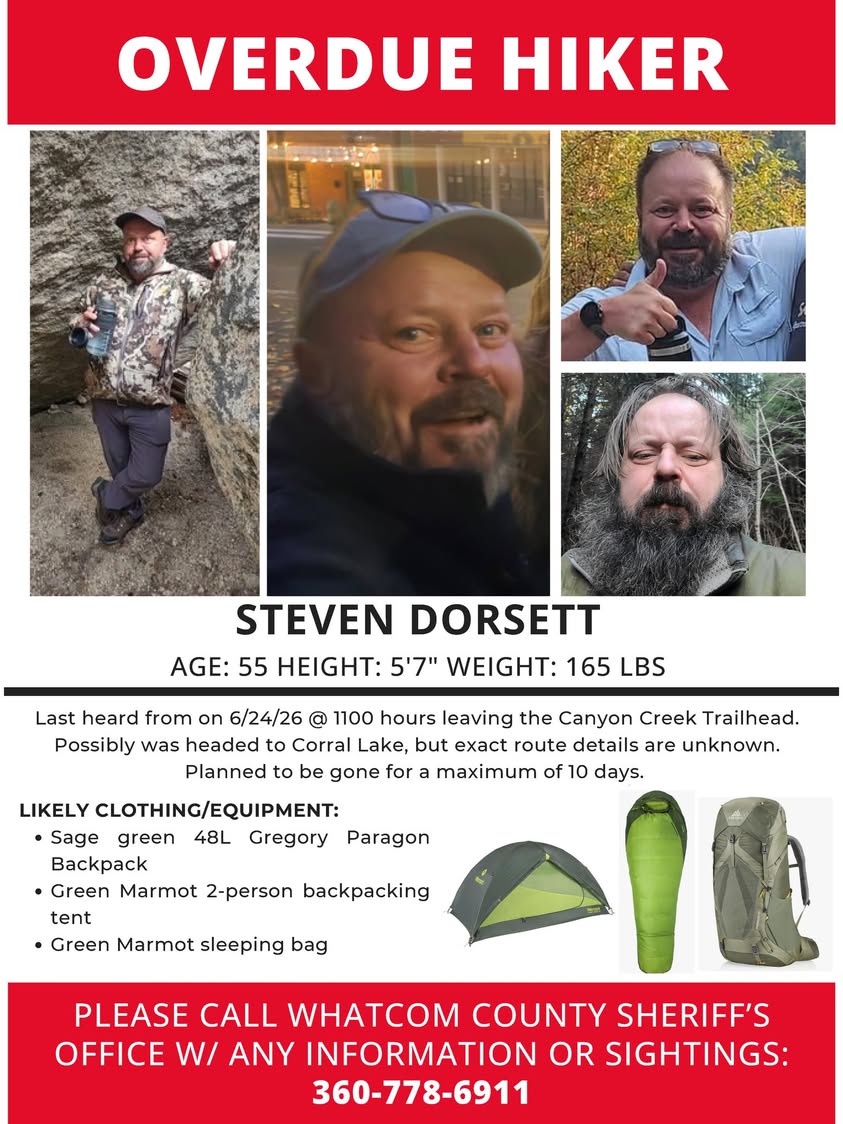
The Whatcom County Sheriff's Office is asking the public to help locate a Bellingham-area hiker who was last in contact on June 24 and is now more than two weeks overdue on a planned backcountry trip in the North Cascades.
Steven Dorsett, 55, was last heard from while leaving the Canyon Creek Trailhead on State Route 20 in southeast Whatcom County, near the boundary of North Cascades National Park. He had planned a roughly 10-day backcountry trip with a goal of reaching Corral Lake and was expected to return around July 5 or 6. When he did not make contact by that date, a family member or contact reported him overdue to law enforcement.
Physical Description and Gear
Deputies released details to help the public identify Dorsett if encountered on the trail or at a trailhead. He is 5 feet 7 inches tall, weighs approximately 165 pounds, and was carrying a green Gregory Paragon 48L backpack. His shelter was a green Marmot two-person tent, and he was using a green Marmot sleeping bag. The combination of green gear could make him less visually conspicuous in forested terrain, something worth considering for anyone who may have seen a solo camper matching that description.
The Canyon Creek Trailhead sits on SR 20 east of Newhalem at roughly the point where the highway enters the national park corridor. The trailhead provides access to the upper Canyon Creek drainage and connecting routes that lead toward the Pasayten Wilderness and the Harts Pass area, some of the most remote terrain in Washington State.
Search Areas of Interest
The Whatcom County Sheriff's Office has identified four specific zones where anyone who recently traveled in the area should check their memories and any trail photographs. Those areas are Harts Pass, accessible from Mazama via a long gravel forest road and one of the highest roadheads in Washington; the Pasayten Trail, which winds through remote wilderness east of the Cascades crest; Big Craggy, a rugged summit area above the Pasayten; and the Pacific Crest Trail, which runs north-south through the entire corridor, connecting dozens of crossing routes.
Anyone who saw a solo hiker matching Dorsett's description in any of these areas, particularly in late June or early July, is urged to call 911 for urgent tips or reach the Sheriff's Office directly at 360-778-6911.
A Challenging Search Environment
The terrain where Dorsett was likely traveling is among the most demanding in Whatcom County for search and rescue operations. The Pasayten Wilderness covers more than half a million acres of roadless land along the Canadian border. Trails are lightly trafficked except during peak summer season, cell service is nonexistent in the backcountry, and the area east of the Cascades crest dries quickly in July, creating conditions that add complexity to extended searches.
The North Cascades backcountry presents unique challenges even for seasoned rescue teams. The area spanning from Canyon Creek to the Canadian border encompasses hundreds of square miles of wilderness terrain with minimal infrastructure. A hiker who encounters an unexpected injury, becomes disoriented, or takes an unplanned shelter during weather would be extraordinarily difficult to locate without a known last position.
Whatcom County Search and Rescue has extensive experience operating in the North Cascades and maintains technical mountain rescue capabilities. Operations in the Pasayten typically involve aerial support and multi-day ground searches coordinated with the National Park Service and the U.S. Forest Service.
How to Help
If you have been in the Canyon Creek, Harts Pass, Pasayten, or Pacific Crest Trail areas of Whatcom County since June 24, review any photographs you took and check your memory for solo hikers matching Dorsett's description. Check trail registers at trailheads if you photographed them. Reach out to any hiking partners who may have encountered a solo camper in those areas.
Reports can be made at any time by calling 911 for urgent tips or the Sheriff's Office non-emergency line at 360-778-6911. Even uncertain sightings are worth reporting so investigators can assess and follow up. Aerial crews working on the nearby Luna Fire along Big Beaver Trail have had assets over parts of the same region, and any relevant observations from those flights could aid the search.